


This tour will spend start from 7 Days
Here the list of Volcano to Trek/Hike on this tour
Maumere: Egon Volcano
Mount Egon is one of the most active and imposing volcanoes in East Flores, located about 30 km from the town of Maumere. Here is a brief overview in English:
Standing at 1,703 meters above sea level, Mount Egon is a stratovolcano known for its massive, deep crater. It is an active volcano that has had several significant eruptions, most notably in 2004 and 2008, which often result in impressive ash plumes.
For adventure seekers, Egon offers one of the most rewarding treks in Flores:
- The Trail: The hike usually takes about 2.5 to 4 hours to reach the rim, starting from the village of Blidit.
- The Landscape: As you ascend, the lush tropical forest transitions into a rugged, “moon-like” landscape dominated by volcanic rocks and the smell of sulfur.
- The Crater: Once at the summit, you are greeted by a vast, smoking crater that is roughly 350 meters wide and 200 meters deep.
From the rim of Mount Egon, you can see a 360-degree view of Sikka Regency. On a clear day, you can see the Maumere Bay to the north and the Sawu Sea to the south, framed by the surrounding green hills.
Quick Travel Tips:
- Best Time: Start your hike very early (around 4:00 or 5:00 AM) to catch the sunrise and avoid the midday heat.
- Guide: It is highly recommended to hire a local guide from Blidit village, as the path can be slippery and obscured by sulfur clouds.
- Preparation: Wear sturdy hiking boots and bring a mask to protect yourself from the strong sulfur fumes at the top.
Ende: IA/Table Volcano
Both Mount Ia and Mount Meja are the iconic natural landmarks that define the skyline of Ende, a historic town on the southern coast of Flores.
Mount Ia is an active stratovolcano located on a small peninsula just south of Ende.
- The Guardian of the Bay: It sits right at the edge of the sea, creating a dramatic backdrop for the town’s harbor.
- Volcanic Activity: It is known for its steep slopes and occasional activity, with its last major eruption occurring in the late 1960s.
- The View: From the top (or even from the waters nearby), it offers a breathtaking panoramic view of the Savu Sea and the surrounding coastline.
Unlike Mount Ia, Mount Meja is famous for its unique and symmetrical shape.
- The “Table” Mountain: Its name, Meja, means “Table” in Indonesian, referring to its distinct flat-topped summit.
- The Legend: Local folklore often connects Mount Meja with Mount Ia and Mount Wongge, telling a story of a tragic love triangle that resulted in these peaks being formed.
- Symbol of Ende: Because of its unusual flat shape, it has become the most recognizable symbol of the city.
Why Visit?
For travelers, these two mountains provide a stunning “frame” for the city of Ende. They are best enjoyed:
- At Sunset: From the coastal roads or “Blue Stone Beach” (Penggajawa), where the silhouettes of these mountains look spectacular.
- For Hiking: Mount Meja offers a relatively easier trek for those wanting to see the town of Ende from above.
Bajawa: Ebulobo
Mount Ebulobo (also known as Embulobo) is one of the most striking natural landmarks in Central Flores, located in the Boawae district, not far from Bajawa.
Ebulobo is a classic stratovolcano famous for its near-perfect symmetrical cone shape. Standing at an elevation of approximately 2,124 meters, it dominates the skyline of the Nagekeo regency and provides a dramatic backdrop for the surrounding traditional villages.
Compared to the more famous Mount Inerie, Ebulobo offers a rugged and authentic trekking experience.
- The Climb: The hike usually takes about 3 to 4 hours to reach the summit and another 2 to 3 hours to descend.
- The Terrain: You will pass through dense forests before reaching the rocky, barren “lava floor” near the crater.
- The Summit: From the top, hikers are rewarded with a 360-degree view of the Flores coastline and the neighboring peaks like Mount Inerie to the west.
The mountain is sacred to the local Ebu people. Most hikers start their journey from Bekek Village, where it is customary (and respectful) to ask for a blessing or guidance from a local elder before starting the ascent.
Quick Travel Tips:
Basecamp: Most travelers stay in Bajawa or Boawae the night before the trek
Best Time: Start your hike at 2:00 AM or 3:00 AM to catch the sunrise at the summit.
Difficulty: Moderate to challenging. It is less steep than Inerie but requires good stamina.
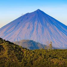
Bajawa: Ine Rie Volcano
Mount Inerie is one of the most iconic natural landmarks in Central Flores, standing tall near the town of Bajawa. Here is a brief overview of this majestic volcano:
Mount Inerie is famous for its almost perfect conical shape, resembling a giant natural pyramid. Standing at $2,245$ meters above sea level, it is one of the highest volcanoes on the island and dominates the skyline of the Ngada district.
For adventure seekers, hiking to the summit is a popular but demanding activity.
- The Path: The trail is quite steep and consists of loose gravel and volcanic scree, which can be slippery.
- The Reward: From the peak, you get a 360-degree view of the southern coast of Flores, the Sawu Sea, and the surrounding lush highlands of Bajawa.
The name “Inerie” translates to “Beautiful Mother” (Ine means mother, Rie means beautiful) in the local language. It is considered a sacred mountain by the Ngada people. At its base lies the famous Bena Traditional Village, where you can see the mountain framed perfectly behind the ancient megalithic courtyards.
Traveler Tips
Location: It is easily accessible from Bajawa, usually taking about a 30-minute drive to the starting point in Watumeze village.
Start Early: Most hikers begin at 3:00 AM or 4:00 AM to reach the summit in time for a spectacular sunrise and to avoid the midday heat.
Preparation: Sturdy hiking boots and trekking poles are highly recommended due to the rocky terrain.
Ruteng: Ranaka Volcano
Mount Ranaka is one of the most prominent natural landmarks near Ruteng, Manggarai.
Standing at approximately 2,140 meters above sea level, Mount Ranaka is an active volcano and the highest point in the Manggarai region. It offers a much cooler climate compared to the coastal areas of Flores.
The mountain gained significant geological attention in 1987 when a massive eruption led to the birth of a new volcanic dome, often referred to as Anak Ranaka. This event transformed the landscape, creating a rugged, blackened lava field that contrasts with the surrounding lush greenery.
It is a popular destination for trekking enthusiasts.
- The Trail: There is a paved access road (originally built for telecommunication towers) that makes the hike relatively manageable compared to other “wild” peaks.
- The View: From the summit, you can enjoy a breathtaking panoramic view of Ruteng town, the surrounding lush valleys, and even the coastline in the distance on a clear day.
The slopes of Mount Ranaka are part of a protected forest area. It is a fantastic spot for birdwatching, as it is home to several endemic species of Flores birds. The area is often shrouded in mist, giving it a mysterious and ethereal atmosphere.
Quick Tips for Visitors:
- Best Time: Start your hike very early (around 4:00 or 5:00 AM) to catch the sunrise and avoid the afternoon fog.
- Preparation: Bring a jacket! Temperatures at the top can be surprisingly chilly, dropping significantly below what you’d expect in the tropics.
- Location: It is located only about 7–9 km from the center of Ruteng, making it an easy day trip.